HC-2100 "Electronic Chart Information and Information System (ECDIS)" is a class A ECDIS product based on IHO S-57 digital chart information. It has passed the test of global navigation.
ECDIS software meets the following international standards:
IHO S57
IHO S52
IHO S63
IEC 61174
IEC 60945
IMO A.694(17)
IMO MSC.191(79)
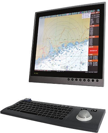
A. An industrial computer with embedded operating system is used as hardware to connect industrial LCD, stainless steel standard keyboard and touch ball, as well as a variety of information sensors to form a set of high-end ECDIS system which meets the "ECS function, performance and test requirements (temporary)" standard.
B. IHO S-57 standard digital chart certified by IHO S-63 can be automatically converted into system digital chart (SENC) according to IHO S-52 standard.
C. Flexible realization of electronic chart information enlargement (including window enlargement), reduction, dragging, center movement, hierarchical control, designated scale, eagle's eye rapid selection and other chart scheduling functions.
D. Tree structure and different priority strategies are used to display various inquired chart information, navigation safety information and so on.
E. Design, Management and Adjustment of Navigation Planning in Various Ways
F. The multi-mode navigation monitoring method which meets the IEC62288 standard realizes the functions of free navigation, planned navigation and emergency navigation respectively.
G. Provide support for multiple movement modes (stability, movement) and various roaming modes (north-up, bow-up, heading-up).
H. According to IEC61174 standard, the ship and its track are drawn, and 24-hour continuous track and 720-hour interval track record and controllable track playback are provided.
I. It can be connected with ship-borne autopilot and display various state parameters of autopilot in various ways, including bow direction, rudder angle, given rudder angle, rudder angular velocity, etc.
J. AIS targets and digital radar targets within the range set by seafarers are displayed according to IEC 61174 standard.
K. 17 kinds of alarms or warnings such as yaw, arrival, mooring, approaching dangerous objects, approaching the boundaries of restricted areas, AIS (CPA/TCPA) and radar (CPA/TCPA) are provided by means of text, color and sound.
L. Five display background options (bright day, normal day, dark day, morning and evening).
M. Various settings (system settings, ship settings, chart loading, etc.) are easy to operate.
a. Support S57 vector chart and raster chart
b. Supporting Radar Image Overlay
c. Support 3D mode
d. Support the access of NMEA equipment such as GPS, AIS, compass, autopilot, bathymeter, etc.
e. Route monitoring
f. Sea Chart Drawing
g. Route design
h. Safety early warning


 中文
中文 English